Data driven styling
Contents
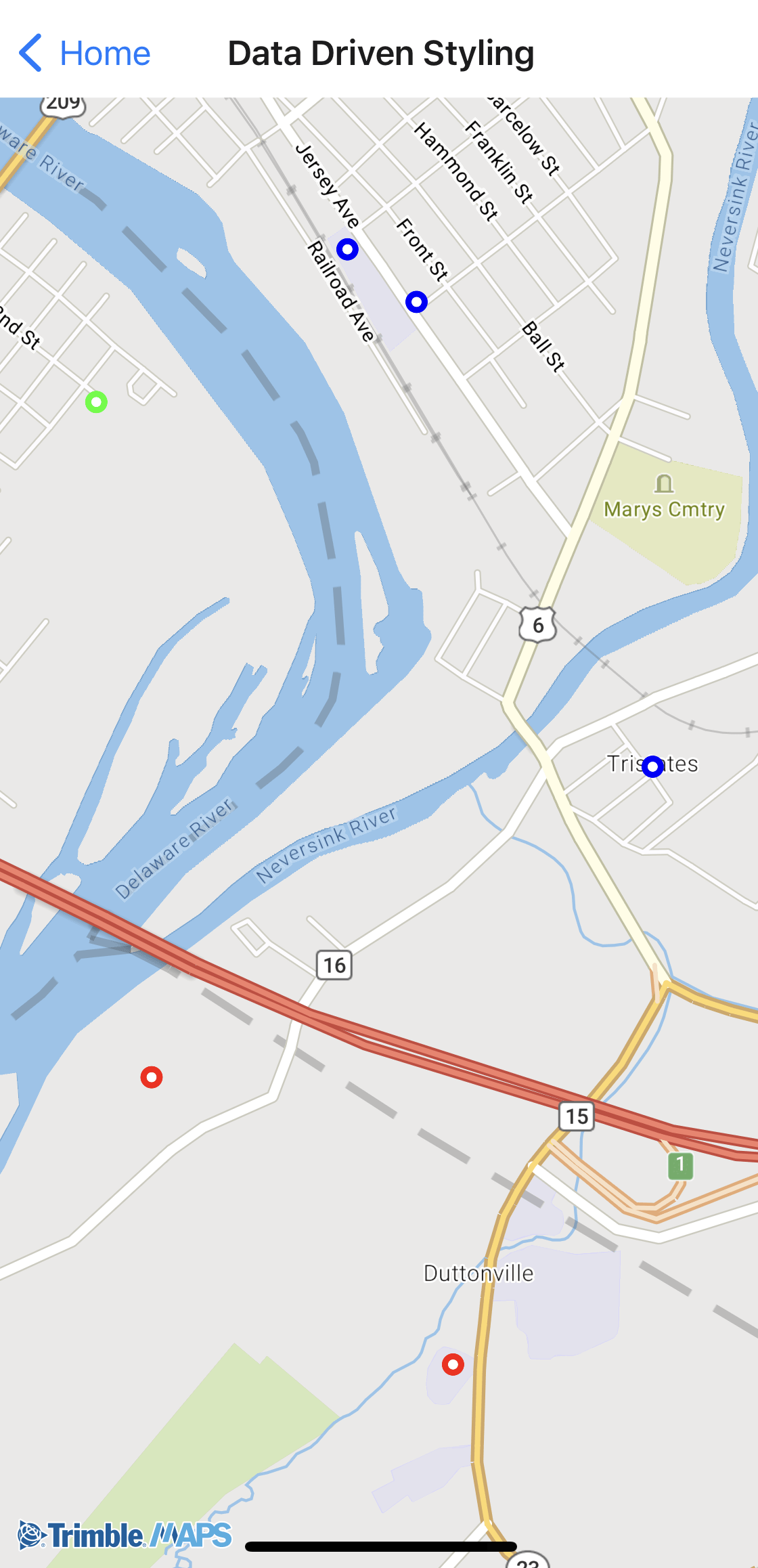
Apply different styles to data depending on specific parameters. In the example below, the points are colored differently based on the state in which they are located. (Green - Pennsylvania; Red - New Jersey; Blue - New York)

Sample code
import React, { useEffect, useState } from "react";
import {
  NativeModules,
  StyleSheet,
  View,
  Platform,
} from "react-native";

import { TrimbleMapsMap } from "./TrimbleMapsMapViewManager";

const TrimbleMapsMapView = NativeModules.TrimbleMapsMapViewModule;
const TrimbleMapsMapViewConstants = TrimbleMapsMapView.getConstants();

export const DataDrivenStyling = () => {
  const [mapLoaded, setMapLoaded] = useState(false);
  const [styleURL, setStyleURL] = useState(null);
  let circleLayerId = "CircleLayerId";
  let circleLayer = "CircleLayer";
  let radiusExpressionKey = "radiusExpression";
  let strokeWidthExpressionKey = "strokeWidthExpression";
  let strokeColorExpressionKey = "strokeColorExpression";

  useEffect(() => {
    // Load the style URL
    TrimbleMapsMapView.MobileDay()
      .then((style) => {
        setStyleURL(style);
      })
      .catch((error) => {
        console.error("Failed to load style:", error);
      });
  }, []);

  useEffect(() => {
    if (mapLoaded) {
      createAndAddCircleLayer();
      moveCamera();

      return () => {
        cleanup();
      };
    }
  }, [mapLoaded]);

  const cleanup = async () => {
    await TrimbleMapsMapView.removeExpression(radiusExpressionKey);
    await TrimbleMapsMapView.removeExpression(strokeWidthExpressionKey);
    await TrimbleMapsMapView.removeExpression(strokeColorExpressionKey);
    await TrimbleMapsMapView.removeGeoJsonSource(circleLayer);
    await TrimbleMapsMapView.removeCircleLayer(circleLayerId);
  };

  const createAndAddCircleLayer = async () => {
    let geojson = require("./assets/tristate.json");
    let geojsonStr = JSON.stringify(geojson);
    await TrimbleMapsMapView.createGeoJsonSource(circleLayer, geojsonStr);

    await TrimbleMapsMapView.addSourceToStyle(circleLayer);

    let circleProperties = {};
    await TrimbleMapsMapView.interpolate(
      radiusExpressionKey,
      "linear",
      "zoom",
      [12, 1, 22, 10]
    );

    await TrimbleMapsMapView.interpolate(
      strokeWidthExpressionKey,
      "linear",
      "zoom",
      [12, 1, 22, 12]
    );

    await TrimbleMapsMapView.matchColor(
      strokeColorExpressionKey,
      "state",
      TrimbleMapsMapViewConstants.BLACK,
      [
        "PA",
        TrimbleMapsMapViewConstants.GREEN,
        "NY",
        TrimbleMapsMapViewConstants.BLUE,
        "NJ",
        TrimbleMapsMapViewConstants.RED,
      ]
    );
    circleProperties[TrimbleMapsMapViewConstants.RADIUS] = "Expression";
    circleProperties["radiusExpressionKey"] = radiusExpressionKey;
    circleProperties[TrimbleMapsMapViewConstants.COLOR] = "#FFFFFF";
    circleProperties[TrimbleMapsMapViewConstants.STROKE_COLOR] = "Expression";
    circleProperties["strokeColorExpressionKey"] = strokeColorExpressionKey;
    circleProperties[TrimbleMapsMapViewConstants.STROKE_WIDTH] = "Expression";
    circleProperties["strokeWidthExpressionKey"] = strokeWidthExpressionKey;

    await TrimbleMapsMapView.createCircleLayerWithProperties(
      circleLayerId,
      circleLayer,
      circleProperties
    );

    await TrimbleMapsMapView.addLayerToStyle(
      circleLayerId,
      TrimbleMapsMapViewConstants.CIRCLE_LAYER
    );
  };

  const moveCamera = async () => {
    if (Platform.OS === "ios") {
      await TrimbleMapsMapView.setCenterCoordinateAndZoom(
        41.362901,
        -74.694676,
        13,
        true
      );
    } else if (Platform.OS == "android") {
      await TrimbleMapsMapView.setZoom(13.0);
      await TrimbleMapsMapView.setTarget(41.362901, -74.694676);
      await TrimbleMapsMapView.buildCameraPosition();
      await TrimbleMapsMapView.moveCamera();
    }
  };

  const onMapLoaded = (e) => {
    setMapLoaded(true);
  };

  const styles = StyleSheet.create({
    container: {
      flex: 1,
    },
    mapStyle: {
      flex: 1,
    },
  });

  if (!styleURL) {
    return <View style={styles.container} />;
  }

  return (
    <View style={styles.container}>
      <View style={styles.container}>
        <TrimbleMapsMap
          style={styles.mapStyle}
          styleURL={styleURL}
          onMapLoaded={onMapLoaded}
        />
      </View>
    </View>
  );
};
tristate.json
{
  "type": "FeatureCollection",
  "features": [
    {
      "type": "Feature",
      "geometry": {
        "type": "Point",
        "coordinates": [-74.68954, 41.369863]
      },
      "properties": {
        "state": "NY"
      }
    },
    {
      "type": "Feature",
      "geometry": {
        "type": "Point",
        "coordinates": [-74.687882, 41.36892]
      },
      "properties": {
        "state": "NY"
      }
    },
    {
      "type": "Feature",
      "geometry": {
        "type": "Point",
        "coordinates": [-74.687007, 41.349811]
      },
      "properties": {
        "state": "NJ"
      }
    },
    {
      "type": "Feature",
      "geometry": {
        "type": "Point",
        "coordinates": [-74.68222, 41.36056]
      },
      "properties": {
        "state": "NY"
      }
    },
    {
      "type": "Feature",
      "geometry": {
        "type": "Point",
        "coordinates": [-74.704292, 41.364475]
      },
      "properties": {
        "state": "PA"
      }
    },
    {
      "type": "Feature",
      "geometry": {
        "type": "Point",
        "coordinates": [-74.710335, 41.360504]
      },
      "properties": {
        "state": "PA"
      }
    },
    {
      "type": "Feature",
      "geometry": {
        "type": "Point",
        "coordinates": [-74.695556, 41.367119]
      },
      "properties": {
        "state": "PA"
      }
    },
    {
      "type": "Feature",
      "geometry": {
        "type": "Point",
        "coordinates": [-74.694232, 41.354974]
      },
      "properties": {
        "state": "NJ"
      }
    },
    {
      "type": "Feature",
      "geometry": {
        "type": "Point",
        "coordinates": [-74.698967, 41.370361]
      },
      "properties": {
        "state": "PA"
      }
    },
    {
      "type": "Feature",
      "geometry": {
        "type": "Point",
        "coordinates": [-74.709572, 41.360474]
      },
      "properties": {
        "state": "PA"
      }
    }
  ]
}