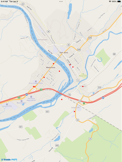
Dots on a map
Contents
The Mobile Maps SDK examples require that you first complete the initial project set-up.
Visualize data on top of the map. Data could vary from simple dots-on-a-map (the example below) to more complex pieces like 3D buildings, route paths, geofences, and more.
DotsOnMapLayer.xaml
<?xml version="1.0" encoding="utf-8" ?>
<ContentPage xmlns="http://schemas.microsoft.com/dotnet/2021/maui"
             xmlns:x="http://schemas.microsoft.com/winfx/2009/xaml"
             x:Class="TrimbleMaps.MapSDK.Sample.DotsOnMapLayer"
             Title="DotsOnMapLayer" xmlns:TrimbleMaps="clr-namespace:TrimbleMaps.Controls.Forms;assembly=TrimbleMaps.MapsSDK">
    <ContentPage.Content>
        <TrimbleMaps:MapView
            x:Name="Map"
            ShowUserLocation="true"
            UserLocationTracking="None"
            ZoomMaxLevel="21"
            CompassEnabled="True"
            CompassFadeFacingNorth="False"
            />
    </ContentPage.Content>
</ContentPage>
DotsOnMapLayer.xaml.cs
using TrimbleMaps.Controls.Forms;
using TrimbleMaps.MapsSDK.Layers;
using TrimbleMaps.MapsSDK.Sources;

namespace TrimbleMaps.MapSDK.Sample
{
    public partial class DotsOnMapLayer : ContentPage
    {
        const string SOURCE_ID = "tristatepoints";
        const string LAYER_ID = "tristatepoints";

        public TrimbleMaps.MapsSDK.Sources.Source source { get; private set; }

        public DotsOnMapLayer()
        {
            InitializeComponent();
            Setup();
        }

        private void Setup()
        {
            Map.Center = new TrimbleMaps.MapsSDK.LatLng(41.36290180612575, -74.6946761628674);
            Map.ZoomMinLevel = 13;
            Map.MapStyle = MapStyle.MOBILE_NIGHT;

            Map.DidFinishLoadingStyleCommand = new Command<MapStyle>(DidFinishLoadingStyleAsync);
        }

        private async void DidFinishLoadingStyleAsync(MapStyle style)
        {
            try
            {
                source = new GeoJsonSource(SOURCE_ID, "dots.json") { IsLocal = true };
                Map.Functions.AddSource(source);
                CircleLayer circleLayer = new CircleLayer(SOURCE_ID, LAYER_ID);
                circleLayer.CircleRadius = 4;
                circleLayer.CircleStrokeColor = Color.FromRgb(255, 0, 0);
                circleLayer.CircleStrokeWidth = 5;
                circleLayer.CircleColor = Color.FromRgb(255, 255, 255);
                // Add the CircleLayer to the map
                Map.Functions.AddLayer(circleLayer);
            }
            catch (Exception e)
            {
                Console.WriteLine($"Error loading GeoJSON: {e.Message}");
            }
        }
    }
}
Sample JSON (tristate.json)
{
  "type": "FeatureCollection",
  "features": [
    {
      "type": "Feature",
      "geometry": {
        "type": "Point",
        "coordinates": [-74.68954, 41.369863]
      },
      "properties": {
        "state": "NY"
      }
    },
    {
      "type": "Feature",
      "geometry": {
        "type": "Point",
        "coordinates": [-74.687882, 41.36892]
      },
      "properties": {
        "state": "NY"
      }
    },
    {
      "type": "Feature",
      "geometry": {
        "type": "Point",
        "coordinates": [-74.687007, 41.349811]
      },
      "properties": {
        "state": "NJ"
      }
    },
    {
      "type": "Feature",
      "geometry": {
        "type": "Point",
        "coordinates": [-74.68222, 41.36056]
      },
      "properties": {
        "state": "NY"
      }
    },
    {
      "type": "Feature",
      "geometry": {
        "type": "Point",
        "coordinates": [-74.704292, 41.364475]
      },
      "properties": {
        "state": "PA"
      }
    },
    {
      "type": "Feature",
      "geometry": {
        "type": "Point",
        "coordinates": [-74.710335, 41.360504]
      },
      "properties": {
        "state": "PA"
      }
    },
    {
      "type": "Feature",
      "geometry": {
        "type": "Point",
        "coordinates": [-74.695556, 41.367119]
      },
      "properties": {
        "state": "PA"
      }
    },
    {
      "type": "Feature",
      "geometry": {
        "type": "Point",
        "coordinates": [-74.694232, 41.354974]
      },
      "properties": {
        "state": "NJ"
      }
    },
    {
      "type": "Feature",
      "geometry": {
        "type": "Point",
        "coordinates": [-74.698967, 41.370361]
      },
      "properties": {
        "state": "PA"
      }
    },
    {
      "type": "Feature",
      "geometry": {
        "type": "Point",
        "coordinates": [-74.709572, 41.360474]
      },
      "properties": {
        "state": "PA"
      }
    }
  ]
}