Data driven styling
Contents
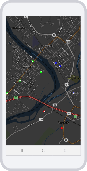
Apply different styles to data depending on specific parameters. In the example below, the points are colored differently based on the state in which they are located. (Green - Pennsylvania; Red - New Jersey; Blue - New York)

import Foundation
import UIKit
import TrimbleMaps
import TrimbleMapsAccounts
import TrimbleMapsWebservicesClient

class DataDrivenStylingViewController: UIViewController, AccountManagerDelegate, TMGLMapViewDelegate {

    internal var mapView: TMGLMapView!

    let SOURCE_ID = "tristatepoints"
    let LAYER_ID = "tristatepoints"

    override func viewDidLoad() {
        super.viewDidLoad()

        let apiKey =  "Your-API-key-here"
        let account = Account(apiKey: apiKey, region: Region.northAmerica)
        AccountManager.default.account = account
        AccountManager.default.delegate = self
    }

    func stateChanged(newStatus: AccountManagerState) {
        if AccountManager.default.isLicensed(licensedFeature: .mapsSdk) {
            if newStatus == .loaded {
                DispatchQueue.main.async {
                    // Create a map view
                    self.mapView = TMGLMapView(frame: self.view.bounds)
                    self.mapView.delegate = self

                    // Set the map location
                    let center = CLLocationCoordinate2D(latitude: 41.36290180612575, longitude: -74.6946761628674)
                    self.mapView.setCenter(center, zoomLevel: 13, animated: false)

                    // Add the map
                    self.view.addSubview(self.mapView)
                }
            }
        } else {
              // Handle the case where the account is not licensed for Maps SDK
              print("Account is not licensed for Maps SDK")
        }
    }

    func mapViewDidFinishLoadingMap(_ mapView: TMGLMapView) {
        // In this example a .json file is being used as the source

        let filePath = Bundle.main.path(forResource: "tristate", ofType: "json")!
        let fileUrl = URL(fileURLWithPath: filePath)

        // Create a source and add it to the style. Important to note, sources are linked to styles.
        // If you change the style you may need to re-add your source and layers
        let shapeSource = TMGLShapeSource(identifier: SOURCE_ID, url: fileUrl, options: .none)
        mapView.style?.addSource(shapeSource)

        // Create a CircleLayer to display our source information.
        let circleLayer = TMGLCircleStyleLayer(identifier: LAYER_ID, source: shapeSource)
        circleLayer.circleColor = NSExpression(format: "TERNARY(booleanProperty=YES, %@, TMGL_MATCH(state, 'PA', %@, 'NY', %@, 'NJ', %@, %@))", UIColor.black, UIColor.green, UIColor.blue, UIColor.red, UIColor.black)

        circleLayer.circleRadius = NSExpression(forConstantValue: 4)

        // add the layer
        mapView.style?.addLayer(circleLayer)
    }

}
Sample JSON (tristate.json)
{
  "type": "FeatureCollection",
  "features": [
    {
      "type": "Feature",
      "geometry": {
        "type": "Point",
        "coordinates": [-74.68954, 41.369863]
      },
      "properties": {
        "state": "NY"
      }
    },
    {
      "type": "Feature",
      "geometry": {
        "type": "Point",
        "coordinates": [-74.687882, 41.36892]
      },
      "properties": {
        "state": "NY"
      }
    },
    {
      "type": "Feature",
      "geometry": {
        "type": "Point",
        "coordinates": [-74.687007, 41.349811]
      },
      "properties": {
        "state": "NJ"
      }
    },
    {
      "type": "Feature",
      "geometry": {
        "type": "Point",
        "coordinates": [-74.68222, 41.36056]
      },
      "properties": {
        "state": "NY"
      }
    },
    {
      "type": "Feature",
      "geometry": {
        "type": "Point",
        "coordinates": [-74.704292, 41.364475]
      },
      "properties": {
        "state": "PA"
      }
    },
    {
      "type": "Feature",
      "geometry": {
        "type": "Point",
        "coordinates": [-74.710335, 41.360504]
      },
      "properties": {
        "state": "PA"
      }
    },
    {
      "type": "Feature",
      "geometry": {
        "type": "Point",
        "coordinates": [-74.695556, 41.367119]
      },
      "properties": {
        "state": "PA"
      }
    },
    {
      "type": "Feature",
      "geometry": {
        "type": "Point",
        "coordinates": [-74.694232, 41.354974]
      },
      "properties": {
        "state": "NJ"
      }
    },
    {
      "type": "Feature",
      "geometry": {
        "type": "Point",
        "coordinates": [-74.698967, 41.370361]
      },
      "properties": {
        "state": "PA"
      }
    },
    {
      "type": "Feature",
      "geometry": {
        "type": "Point",
        "coordinates": [-74.709572, 41.360474]
      },
      "properties": {
        "state": "PA"
      }
    }
  ]
}