Clickable Points
Contents
The Mobile Maps SDK examples require that you first complete the initial project set-up.
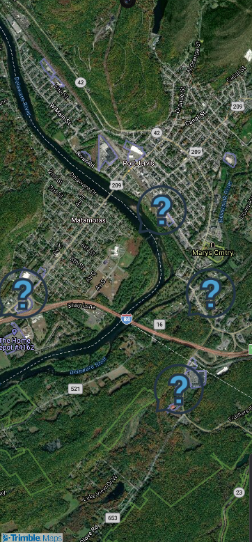
Example showing how to click on locations on the map and display any associated data.
activity_sample_framing.xml
<?xml version="1.0" encoding="utf-8"?>
<FrameLayout android:layout_height="match_parent"
    xmlns:android="http://schemas.android.com/apk/res/android"
    android:layout_width="match_parent">

    <com.trimblemaps.mapsdk.maps.MapView
        android:id="@+id/mapView"
        android:layout_width="match_parent"
        android:layout_height="match_parent" />

</FrameLayout>
Sample Code
Before running the Java or Kotlin code, the theme needs to be set in the Theme.xml file as shown below.
<?xml version="1.0" encoding="utf-8"?>
<resources>
    <style name="Theme.AsyncAcctInit" parent="Theme.AppCompat" />
</resources>
import android.app.Activity;
import android.graphics.BitmapFactory;
import android.graphics.Color;
import android.graphics.PointF;
import android.os.Bundle;
import androidx.appcompat.app.AlertDialog;
import com.trimblemaps.geojson.Feature;
import com.trimblemaps.geojson.FeatureCollection;
import com.trimblemaps.geojson.Point;
import com.trimblemaps.mapsdk.TrimbleMaps;
import com.trimblemaps.mapsdk.camera.CameraPosition;
import com.trimblemaps.mapsdk.geometry.LatLng;
import com.trimblemaps.mapsdk.maps.MapView;
import com.trimblemaps.mapsdk.maps.Style;
import com.trimblemaps.mapsdk.maps.TrimbleMapsMap;
import com.trimblemaps.mapsdk.style.layers.PropertyFactory;
import com.trimblemaps.mapsdk.style.layers.SymbolLayer;
import com.trimblemaps.mapsdk.style.sources.GeoJsonSource;
import java.io.BufferedReader;
import java.io.InputStreamReader;
import java.util.List;

public class SampleClickablePointsActivity extends Activity implements Style.OnStyleLoaded {
    private MapView mapView;
    private TrimbleMapsMap map;
    private static final String SOURCE_ID = "tristatepoints";
    private static final String LAYER_ID = "tristatepoints";
    private static final String ICON_ID = "location-icon";

    @Override
    protected void onCreate(Bundle savedInstanceState) {
        super.onCreate(savedInstanceState);

		// Authorize the API key for the session.
        // .apiKey() requires your Trimble Maps API key
        TrimbleMapsAccount trimbleMapsAccount = TrimbleMapsAccount.builder()
                .apiKey("Your-API-key-here")
                .addLicensedFeature(LicensedFeature.MAPS_SDK)
                .build();

        // Initialize the session
        TrimbleMapsAccountManager.initialize(trimbleMapsAccount);
        TrimbleMapsAccountManager.awaitInitialization();

        // Get an instance of the map, done before the layout is set.
        TrimbleMaps.getInstance(this);
        setContentView(R.layout.activity_sample_clickable_points);

        // Set up the MapView from the layout
        mapView = findViewById(R.id.mapView);

        // the onMapReadyCallback is fired when the map is ready to be worked with
        mapView.getMapAsync(trimbleMapsMap -> {
            map = trimbleMapsMap;
            CameraPosition position = new CameraPosition.Builder()
                    .target(new LatLng(41.36290180612575, -74.6946761628674))
                    .zoom(13.0)
                    .build();
            map.setCameraPosition(position);
            map.setStyle(Style.TrimbleMobileStyle.MOBILE_SATELLITE, this);
        });
    }

    @Override
    public void onStyleLoaded(Style style) {
        // Add the icon to the style
        style.addImage(ICON_ID, BitmapFactory.decodeResource(getResources(), R.drawable.basic_icon_faqs));

        // Load points from the GeoJson file
        try {
            InputStreamReader inputStream = new InputStreamReader(getAssets().open("tristate.json"));
            BufferedReader bufferedReader = new BufferedReader(inputStream);
            StringBuilder stringBuilder = new StringBuilder();
            String line;
            while ((line = bufferedReader.readLine()) != null) {
                stringBuilder.append(line);
            }
            String geoJson = stringBuilder.toString();
            FeatureCollection featureCollection = FeatureCollection.fromJson(geoJson);

            // Create a GeoJsonSource with the loaded data
            GeoJsonSource source = new GeoJsonSource(SOURCE_ID, featureCollection);
            style.addSource(source);

            // Create a SymbolLayer to display our source information as icons
            SymbolLayer symbolLayer = new SymbolLayer(LAYER_ID, SOURCE_ID);
            symbolLayer.setProperties(
                    PropertyFactory.iconImage(ICON_ID),
                    PropertyFactory.iconSize(1.0f),
                    PropertyFactory.iconColor(Color.RED)
            );

            // Add the layer
            style.addLayer(symbolLayer);

            // Set up a click listener to show a popup with state and coordinates information
            map.addOnMapClickListener(point -> {
                PointF screenPoint = map.getProjection().toScreenLocation(point);
                List<Feature> features = map.queryRenderedFeatures(screenPoint, LAYER_ID);
                if (!features.isEmpty()) {
                    Feature feature = features.get(0);
                    String state = feature.getStringProperty("state");
                    List<Double> coordinates = ((Point) feature.geometry()).coordinates();
                    String message = "State: " + state + "\nCoordinates: " + coordinates;

                    // Create and show the popup
                    new AlertDialog.Builder(this)
                            .setTitle("Location Info")
                            .setMessage(message)
                            .setPositiveButton("OK", (dialog, which) -> dialog.dismiss())
                            .show();
                }
                return true;
            });
        } catch (Exception e) {
            e.printStackTrace();
        }
    }

    @Override
    public void onStart() {
        super.onStart();
        mapView.onStart();
    }

    @Override
    public void onResume() {
        super.onResume();
        mapView.onResume();
    }

    @Override
    public void onPause() {
        super.onPause();
        mapView.onPause();
    }

    @Override
    public void onStop() {
        super.onStop();
        mapView.onStop();
    }

    @Override
    public void onLowMemory() {
        super.onLowMemory();
        mapView.onLowMemory();
    }

    @Override
    public void onDestroy() {
        super.onDestroy();
        mapView.onDestroy();
    }

    @Override
    public void onSaveInstanceState(Bundle outState) {
        super.onSaveInstanceState(outState);
        mapView.onSaveInstanceState(outState);
    }
}
import android.app.Activity
import android.graphics.BitmapFactory
import android.graphics.Color
import android.os.Bundle
import android.view.View
import androidx.appcompat.app.AlertDialog
import com.trimblemaps.geojson.FeatureCollection
import com.trimblemaps.geojson.Point
import com.trimblemaps.mapsdk.TrimbleMaps
import com.trimblemaps.mapsdk.camera.CameraPosition
import com.trimblemaps.mapsdk.geometry.LatLng
import com.trimblemaps.mapsdk.maps.MapView
import com.trimblemaps.mapsdk.maps.Style
import com.trimblemaps.mapsdk.maps.TrimbleMapsMap
import com.trimblemaps.mapsdk.style.layers.PropertyFactory
import com.trimblemaps.mapsdk.style.layers.SymbolLayer
import com.trimblemaps.mapsdk.style.sources.GeoJsonSource
import java.io.InputStreamReader

class SampleClickablePointsActivity : Activity(), Style.OnStyleLoaded {
    private var mapView: MapView? = null
    private var map: TrimbleMapsMap? = null
    private val SOURCE_ID = "tristatepoints"
    private val LAYER_ID = "tristatepoints"
    private val ICON_ID = "location-icon"

    override fun onCreate(savedInstanceState: Bundle?) {
        super.onCreate(savedInstanceState)

		// Authorize the API key for the session.
        // .apiKey() requires your Trimble Maps API key
		val trimbleMapsAccount = TrimbleMapsAccount.builder()
			.apiKey("Your-API-key-here")
			.addLicensedFeature(LicensedFeature.MAPS_SDK)
			.build()

		// Initialize the session
		TrimbleMapsAccountManager.initialize(trimbleMapsAccount)
		TrimbleMapsAccountManager.awaitInitialization()

        // Get an instance of the map, done before the layout is set.
        TrimbleMaps.getInstance(this)
        setContentView(R.layout.activity_sample_clickable_points)

        // Set up the MapView from the layout
        mapView = findViewById<View>(R.id.mapView) as MapView

        // the onMapReadyCallback is fired when the map is ready to be worked with
        mapView?.getMapAsync { trimbleMapsMap -> // The TrimbleMapsMap object is created, now a style can be applied to render a map.
            map = trimbleMapsMap
            val position = CameraPosition.Builder()
                .target(LatLng(41.36290180612575, -74.6946761628674))
                .zoom(13.0)
                .build()
            map?.cameraPosition = position
            map?.setStyle(Style.TrimbleMobileStyle.MOBILE_SATELLITE, this@SampleClickablePointsActivity)
        }
    }

    override fun onStyleLoaded(style: Style) {
        // Add the icon to the style
        val iconBitmap = BitmapFactory.decodeResource(resources, R.drawable.basic_icon_faqs)
        style.addImage(ICON_ID, iconBitmap)

        // Load points from the GeoJson file
        try {
            val inputStream = assets.open("tristate.json")
            val geoJson = InputStreamReader(inputStream).readText()
            val featureCollection = FeatureCollection.fromJson(geoJson)

            // Create a GeoJsonSource with the loaded data
            val source = GeoJsonSource(SOURCE_ID, featureCollection)
            style.addSource(source)

            // Create a SymbolLayer to display our source information as icons
            val symbolLayer = SymbolLayer(LAYER_ID, SOURCE_ID)
            symbolLayer.setProperties(
                PropertyFactory.iconImage(ICON_ID),
                PropertyFactory.iconSize(1.0f),
                PropertyFactory.iconColor(Color.RED)
            )

            // Add the layer
            style.addLayer(symbolLayer)

            // Set up a click listener to show a popup with state and coordinates information
            map?.addOnMapClickListener { point ->
                val screenPoint = map?.projection?.toScreenLocation(point)
                val features = map?.queryRenderedFeatures(screenPoint!!, LAYER_ID)
                if (!features.isNullOrEmpty()) {
                    val feature = features[0]
                    val state = feature.getStringProperty("state")
                    val coordinates = (feature.geometry() as Point).coordinates()
                    val message = "State: $state\nCoordinates: $coordinates"

                    // Create and show the popup
                    AlertDialog.Builder(this)
                        .setTitle("Location Info")
                        .setMessage(message)
                        .setPositiveButton("OK") { dialog, _ -> dialog.dismiss() }
                        .show()
                }
                true
            }
        } catch (e: Exception) {
            e.printStackTrace()
        }
    }

    override fun onStart() {
        super.onStart()
        mapView?.onStart()
    }

    override fun onResume() {
        super.onResume()
        mapView?.onResume()
    }

    override fun onPause() {
        super.onPause()
        mapView?.onPause()
    }

    override fun onStop() {
        super.onStop()
        mapView?.onStop()
    }

    override fun onLowMemory() {
        super.onLowMemory()
        mapView?.onLowMemory()
    }

    override fun onDestroy() {
        super.onDestroy()
        mapView?.onDestroy()
    }

    override fun onSaveInstanceState(outState: Bundle) {
        if (outState != null) {
            super.onSaveInstanceState(outState)
            mapView?.onSaveInstanceState(outState)
        }
    }
}