Maps SDK Release Notes
Contents
Draw Tool Add-on v1.0.4
June 2025
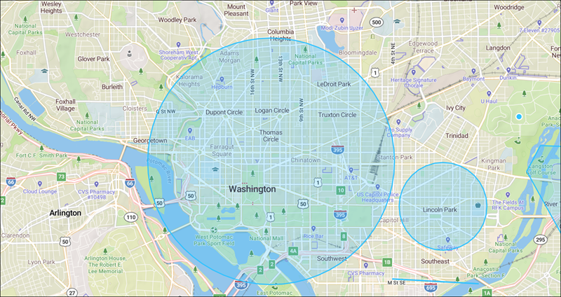
IMPROVEDAdded a new tool to draw circles on the map.
Maps v3.22.4
June 2025
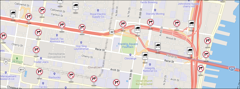
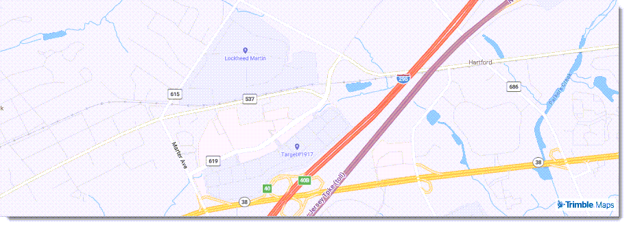
IMPROVEDAdded support for passing a ZIP code without coordinates to the RoutePath and Report services.FIXEDImproved handling of API responses with 204 No Content.FIXEDFixed issues with truck restrictions on the map, including the display of turn restrictions on roads that have no turns.
Maps v3.22.3
April 2025
FIXEDFixed route option region and dataversion value when no default value is set to map.FIXEDFixed the default data version for route options.FIXEDFixed an issue where active route stops were not highlighted on the map.
Maps v3.22.1
March 2025
IMPROVEDAdded a new method to log whether content layers have been successfully loaded. Acontent.add eventis displayed in the console to verify the layer has been added.FIXEDFixed a Points of Interest (POI) console error in the Map Menus add-on.
Maps v3.22.0
February 2025
IMPROVEDImproved the display of details in Places pop-ups.
IMPROVEDAdded turn restrictions to the Truck Restrictions map layer.
-
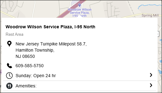
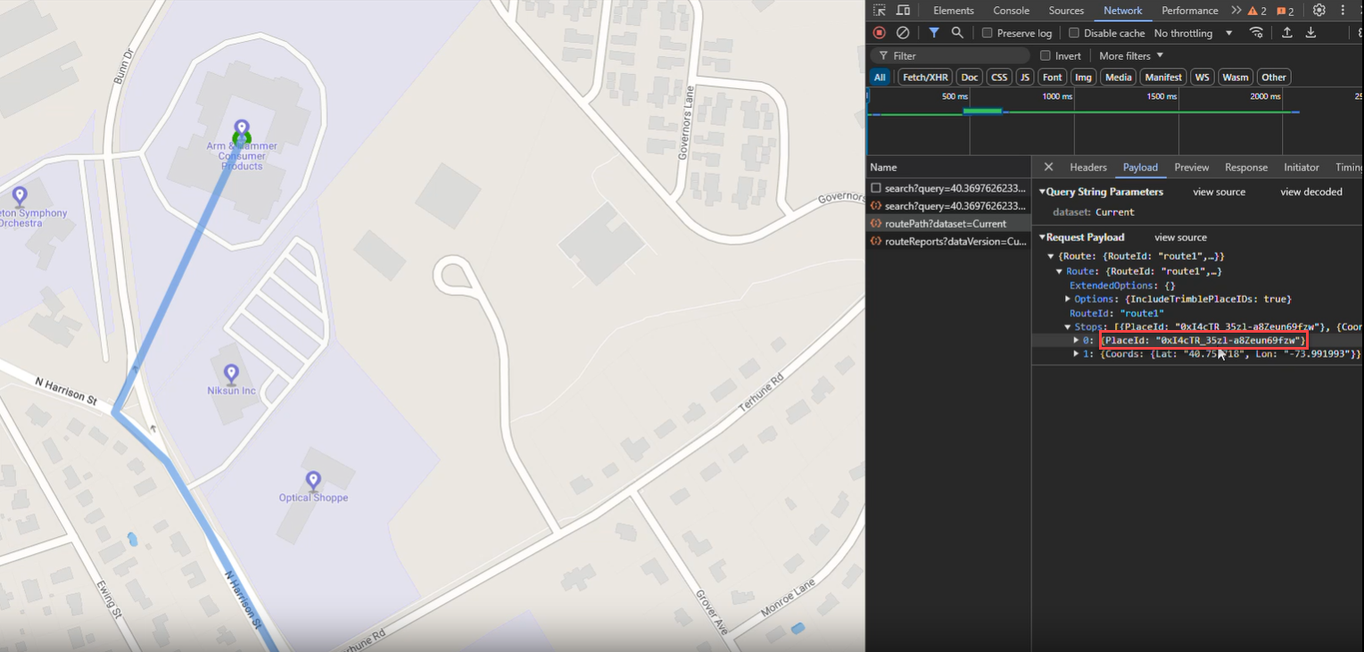
IMPROVEDThePlaceIdparameter can now be included in route path and route reports API calls. This allows for routing to your company’s private (custom) places created in ContentTools or created with the Places API. -
FIXEDFixed the display of traffic flow in the Oceania region so it does not overlap other icons. -
FIXEDFixed console errors when clicking certain truck restriction icons.
Maps v3.21.0
November 2024
IMPROVEDWhen you drag and drop the route path on the map to create a new stop to a Place (custom or public), theplaceIdof that place is now passed inroutePathandrouteReportrequests.
Maps v3.20.0
October 2024
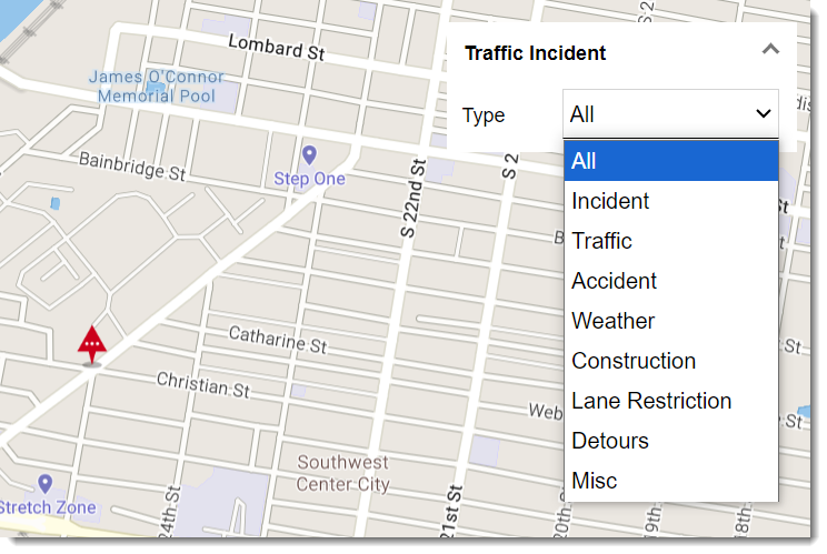
IMPROVEDUpdated the available categories in the Traffic Incident map control.
IMPROVEDImproved the visibility of border lines between states.
-
IMPROVEDUpdated waypoint icons. -
FIXEDFixed the display of building polygons and the opacity of 3D buildings on mobile devices.
Maps v3.19.0
October 2024
IMPROVEDAdded thePlaceClickControlto the Trimble Maps declaration file.FIXEDFixed anUncaught TypeErrorwhen performing a location search with coordinates in certain regions.
Maps v3.18.0
August 2024
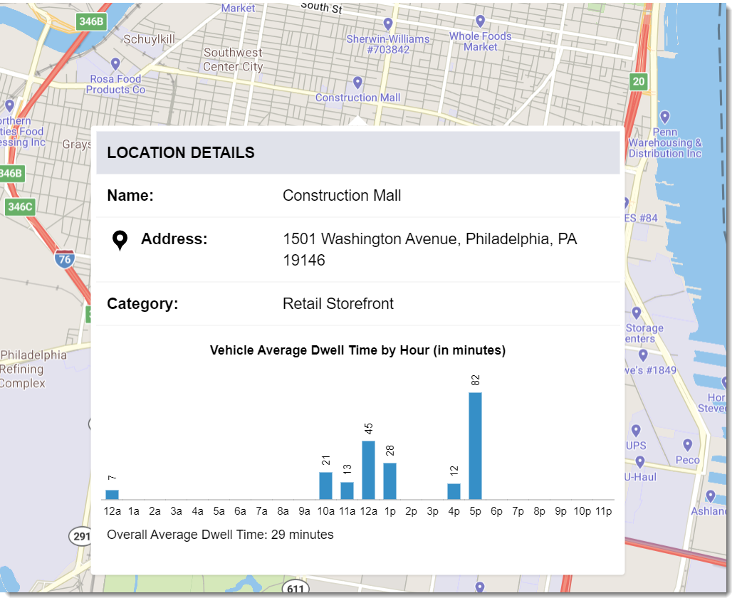
IMPROVEDThe error message for an Invalid LngLat now includes the incorrect value to help you identify and correct it.FIXEDFixed the time labels in a Vehicle Average Dwell Time chart.FIXEDFixed console errors when 16 or more routes are added to map.
Maps v3.17.0
May 2024
FIXEDFixed the display of truck restrictions in metric units.FIXEDFixed the display of add-on controls to show the full panel.FIXEDFixed the coloring of the Weather Alerts display in dark mode.
Single Search v1.1.5
May 2024
IMPROVEDImproved accessibility support for screen readers using ARIA labels.
Route Modifiers v1.0.4
May 2024
IMPROVEDThe update adds the ability to catch errors from the modifier control and handle them in the application.
Adding:
myMap.on('rmerrors', (e) => {
  // gets the routeModifiers errors.
  console.warn(e);
});
Allows the application to listen for modifier specific errors and handle them appropriately.
Maps v3.16.0
April 2024
FIXEDRemoved unwanted unit conversions when not using thesetUnitparameter.FIXEDFixed theCalendarDateoption ofEstimatedTimeOptsfor Route Path and Route Report requests so that the format is MM/DD/YYYY for all regions.FIXEDFixed the display of basic places in Europe.
Maps v3.15.0
March 2024
-
FIXEDRemoved Scrollbar Global Style from the CSS -
NEWFor web apps with a strict Content Security Policy (CSP), CSP JS and Worker JS files are now available.
Custom Places v1.0.6
February 2024
FIXEDFixed an issue preventing the Custom Place details pop-up from displaying.
Maps v3.14.0
February 2024
-
IMPROVEDMade performance and stability improvements to traffic layers including traffic incidents and traffic cameras. -
IMPROVEDWhenhubRoutingis enabled, the route path and stop icons are now displayed in the same color. -
FIXEDChanged the border radius for map controls to 4 pixels from 2 pixels.
Maps v3.13.0
January 2024
-
IMPROVEDImproved the drag route feature to provide users with more visual feedback on the map when dragging a route. -
IMPROVEDAdditional details are now included in theclickpopupcontentloadevent. These details can be used to customize standard pop-ups in the SDK. -
IMPROVEDAdded an option in the SDK to set size and distance units toMETRICorENGLISH. -
FIXEDFixed the display of pop-up controls in dark mode. -
FIXEDFixed issues with the weather alert filter control that occurred when changing map styles. -
FIXEDFixed errors that occurred when more than 16 routes were added to a map. Note: The SDK won’t automatically assign new route colors for more than 16 routes; a default color will be used unless arouteColoris provided in route options.
Custom Places v1.0.5
December 2023
IMPROVEDAdded a search filter and search progress icon to the custom places pop-up.
Maps v3.12.0
November 2023
NEWDwell time data can now be displayed in a Place pop-up if that data is available for a location. (Requires additional licensing)
IMPROVEDWhen routing to a Trimble Place or a Custom Place, the route line is drawn on the map directly to the place, rather than to the nearest road link.
-
IMPROVEDA newshowPopupoption was added to the click controls. It allows you to prevent a pop-up from being displayed but still retrieve the pop-up’s data (place data, road restriction data, etc.) and build it into your own custom pop-up. -
IMPROVEDFilters were enhanced in map controls.
Custom Places v1.0.4
November 2023
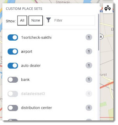
IMPROVEDEnhancements were made to the styling of the Custom Places map control as well as to how place sets are displayed within the control.
Map Menus v1.0.6
November 2023
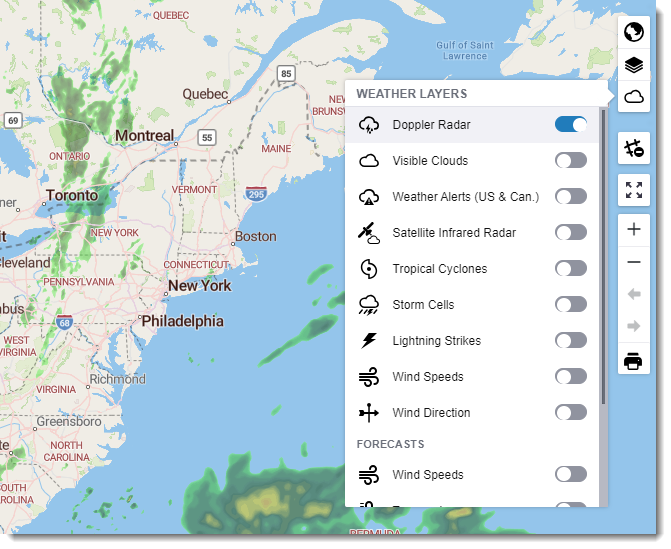
IMPROVEDThe weather layers control was updated to include new content ranging from Doppler radar to wind speeds and direction.
Route Modifiers v1.0.3
November 2023
IMPROVEDEnhancements were made to the styling of the Route Modifiers map control as well as to how modifiers can be filtered within the control.
Single Search v1.1.3
November 2023
IMPROVEDThe Single Search control now includes a spinning search progress indicator and a message if no results are found.
Maps v3.11.0
September 2023
-
IMPROVEDVarious styling changes were made to allow the display of maps, pop-ups, and controls in dark mode. -
IMPROVEDAdditional display options were added to the Weather Radar layer, including temperatures and wind speeds. -
FIXEDFixed an issue that could prevent the Trimble Places pop-up from being displayed on the map. -
FIXEDFixed an issue where the map would automatically zoom in or zoom out after changing the map style.
Custom Places v1.0.3
September 2023
IMPROVEDThe custom places layer can now be shown without the built-in map control.IMPROVEDIn the control panel, custom place sets can now all be turned off by default, and the user can select only the individual sets they want to display.
Maps v3.10.0
June 2023
-
IMPROVEDAprofileIdparameter was added to theRouteOptionsobject as a way to select the Vehicle Routing Profile used to create a route. A routing profile is a preset collection of vehicle dimensions and other routing options that ensure the routing algorithm knows the type of vehicle being driven so it can generate a safe, efficient, and legal route. -
FIXEDFixed an issue that caused console errors when dragging a route.
Maps v3.9.0
April 2023
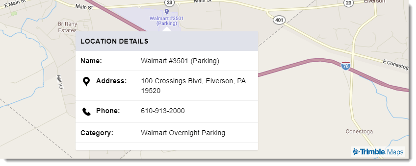
NEWA pop-up can now be displayed when a user clicks a Trimble Maps Place on the map. The pop-up provides details about that place, which may include its address, hours of operation, services, and contact information. Trimble Maps maintains an ever-growing Places database that includes millions of commercial locations across North America that serve the transportation industry.
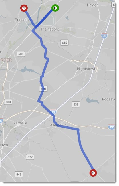
NEWHub routing was added to the optionalRouteOptionswhen creating a route. Hub Routing generates routes from a single starting place (origin) to multiple destinations. By default, the hub will be green with a label H, and destinations will be red and numbered.
-
IMPROVEDImprovements were made to the styling of route lines displayed on the map. -
IMPROVEDA style change event is now triggered whenever the map style changes. -
IMPROVEDAnisVisiblesetting is now available as an initial option for route and content layers.
Maps v3.8.0
February 2023
IMPROVEDAdjusted the way cities are displayed on the map at each zoom level in order to: - More evenly distribute the cities that are displayed. - Continue to give preference to displaying larger cities at higher zoom levels.IMPROVEDIncreased the number of Trimble Maps Places available and enhanced the styling of how they are displayed on the map. Places are commercial locations across North America that serve the transportation industry, ranging from distribution centers and manufacturing facilities to truck stops and rest areas. They include a boundary polygon that can be used to determine when a truck route enters or exits that place.
Maps v3.7.0
September 2022
-
NEWAdded three new methods related to the display of routes on the map:setVisibility,isVisible, andtoggleVisibility. -
IMPROVEDAdded a new, premium option to display curated satellite images on the map. -
IMPROVEDAddedRoadto the types of reports available. A Road report provides a distance breakdown by road category for each leg of the route. -
FIXEDFixed an error caused when adding astopOptionsobject.
Maps v3.6.0
August 2022
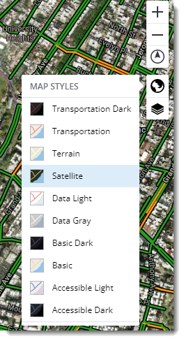
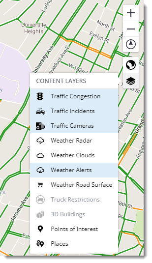
NEWMap Styles and Content Layers controls can now be added to the map.
Map Styles
Content Layers
-
IMPROVEDSeveral improvements were made to the way commercial vehicle routes can be created and displayed on the map. You can now:- Select a vehicle routing profile by name.
- Filter the display of truck restrictions on the map based on any of the following truck attributes: Vehicle Type (Truck, Light Truck, or Car), Height, Length, Width, Weight, Axles, and Multiple Trailer.
- Include more details about each stop on a route, including a name, ID, and cost details.
-
IMPROVEDImproved the interaction between map controls and content layers for better visibility. -
IMPROVEDImproved the amount of detail provided with routing error messages. -
IMPROVEDImproved city name translations. -
FIXEDFixed an error that was triggered when hiding stop icons.
Maps v3.5.0
June 2022
-
NEWSingle Search Geocoding is now an option for all geocoding calls when mapping locations or drawing routes on the map. You can also add a search text box for map end users with the Single Search Add-on. -
NEWA listener can now be created to determine when a map user is clicking on or hovering over an origin icon, destination icon, or intermediate stop icon for a route drawn on a map. -
IMPROVEDMap styles and assets were updated for improved visualization. -
IMPROVEDWaypoints created by dragging a route on the map can now be deleted by hovering over the waypoint and right-clicking while pressing the Alt key. -
FIXEDImproved the accuracy of “snapping” a route to a nearby road when the route is dragged to a new location on the map. -
FIXEDChanged the default text font setting to['Open Sans Regular', 'Noto Sans Regular']. -
FIXEDFixed an error that caused a layer to be re-added to the map even when its visibility was set to false. -
FIXEDFixed an issue that could produce an error when callingmyRoute.remove().
Maps v3.4.0
January 2022
IMPROVEDAdded the following new map styles: MOBILE_DAY, MOBILE_NIGHT, MOBILE_SATELLITE, and ACCESSIBLE_DARK.
Maps v3.3.0
November 2021
-
IMPROVEDThe styling of how exit ramp names are displayed has been improved. -
IMPROVEDSeveral enhancements were made to the drag routes feature, which allows you to edit a route path directly on the map:- Dragging can be limited so that routes only snap to roads visible at the map’s current zoom level. This new feature can be turned off completely or controlled (turned on or off) by holding a specified modifier key while dragging the route. (Shift is the default key.)
- When dragging and snapping a route, a nearby road segment is highlighted. If there is no road nearby, the cursor turns to a “not-allowed” state and if the mouse button is released, the drag is cancelled.
Maps v3.2.0
October 2021
-
NEWRoute modifiers, which are roads that should be avoided or favored, can now be applied to a route using one of two new parameters:afSetIDs- The IDs of the Route Modifier (avoid/favor) sets that should be applied to the route.afSetNames- The names of the Route Modifier sets that should be applied to the route. Default is an empty set.
-
NEWBasic Dark and Transportation Dark map styles are now available. -
NEWArrows can now be added to the map to indicate the direction of travel along the route. -
NEWA newframeOptionssetting allows you to change the default behavior of shifting and zooming to frame a route on the map. -
IMPROVEDAdditional options are now available that customize the way a route is generated based on the type of vehicle being driven, as well as a fleet’s preferences for how that vehicle should be routed. The options match those available in our Routing APIs.
Maps v3.1.0
September 2021
NEWThe following new map layers were added: - A traffic camera layer that allows you to display current traffic cameras and images within given bounds. - A traffic incident layer that allows you to display current traffic incidents.
NEWThe following optional parameters were added toRouteOptions: -hazMatTypesallows you to select an array of hazardous materials types to be applied to a route request. -useTrafficindicates whether to use traffic when calculating trip transit times. -frameRouteprevents the route from being framed on the map if set tofalse. -classOverrideallows you to select whether a truck with a 48’ or shorter trailer should still adhere to routing for larger (53’) trucks on the State/National Network. Trucks over 48’ are automatically routed on the State/National Network. (U.S. only)
IMPROVEDAdded support for additional currencies worldwide in toll calculations.
FIXEDFixed bugs in the routing layer relating to zooming and flow problems.
FIXEDFixed an issue that preventedWeatherAlertFilterControlfrom updating.
Maps v3.0.0
July 2021
-
NEWThe JavaScript Maps SDK v3 incorporates a wide range of enhancements in how maps are rendered using the latest version of Mapbox GLJS (v1.12). It includes enhanced map controls, styling, 3D capabilities, and other features for a high level of detail and customization.Highlights of the release include:
-
Custom 3D layers. With a custom style layer using three.js, you can add 3D models to the map, including Trimble-owned content from the SketchUp team.
-
Improved gesture support on desktop and mobile. Three new touch gestures have been added: two-finger swipe to adjust pitch, two-finger double tap to zoom out, and tap and drag to adjust zoom with one finger.
-
New events to track map rendering. A new
idleevent fires when no further rendering is expected. -
New map initialization options (bounding box). New
boundsandfitBoundsOptionsmap constructor options can be used to indicate the initial map view in place ofcenterandzoom. -
Improved popups. New features include an option to set
maxWidth, which defaults to240px, and the option forcloseOnMovewhich, when set totrue, closes the popup when the map’s position changes. -
Updated clustering and data sources. This includes a
clusterPropertiesoption for aggregated cluster properties, and methods for changing a vector tile source dynamically (e.g.setTiles,setUrl)
Existing users can upgrade to the latest version by updating the version number in the JavaScript and CSS files in the
<head>of your HTML file. Contact us if you are not a licensed Maps user and would like to learn more. -